Adım Adım Amasya

Monuments of the city · Bridge

Çağlayan Bridge

Five kilometres outside the city, inside the gorge. One of Amasya's oldest bridges — and it carries a secret.

1075–1150 (estimate) Danishmendid Güney Boğazı
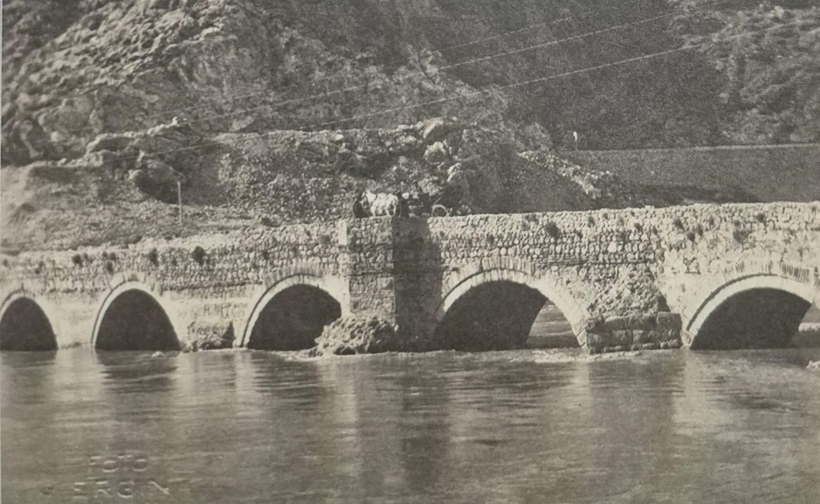
The Çağlayan Bridge: a five-arched bridge on stone piers at the foot of a rocky slope; above one of the piers an angular projection rises above the parapet; the still Yeşilırmak in front
The Çağlayan Bridge. Hüseyin Menç Archive (Kültürel Miras Boyutuyla Amasya, Photo 24).

Look carefully at the picture. Above the arches, right on top of one of the piers, there is an angular projection that rises above the line of the parapet. That projection is no ordinary heap of stones: researchers think it is a “tarih köşkü” — a small pavilion in which the bridge's inscription stood.1

So the stone that told who built the bridge, and when, was probably there. It is gone today. All the uncertainty on this page comes from that lost stone.

📜 What do the documents say?

The bridge stands about 5 km outside the centre of Amasya, on the Tokat highway at the Eryatağı junction. It lies south-west of the city, at the spot people call “Ferhat Arası” or “Güney Boğazı” (the Southern Gorge).1

The year it was built and who built it are not known for certain. The general view is that it was built at some time between 1075 and 1150 by İltekin Gazi, one of the Danishmendid emirs, or his son Hüsamüddevle Hasan.1

But one line of reasoning favours a particular estimate: according to some sources, this bridge was built to make it easier to move the troops used in the siege of Amasya. If so, it is reasonable to take İltekin Gazi as its builder and 1075 as its year.1 According to Abdizade Hüseyin Hüsameddin, however, the bridge was built in 1076 by the Danishmendid emir İltekin Gazi.2

  • 70 mlength of the bridge1
  • Stonepiers1
  • Brickarches1

On the western sides of the piers there are triangular cutwaters — projections that break the force of the water and split the current in two.1 The use of dressed stone together with brick, and especially the use of red brick in the arches and piers, is taken as a sign that the building belongs to the Danishmendid period.1

An army stood at the foot of this bridge

The most famous day in Amasya of the man whose name the bridge bears was lived out exactly where the bridge crosses the river.

Spring 1075 Having conquered Kayseri, Tokat and Niksar, Melik Danişmend Ahmed Gazi spends the winter at Kaşan (Turhal) and then marches with his army on Harşena. One of his commanders, İltekin Gazi, takes up position before the southern gorge of Amasya — that is, level with today's Derbent vineyards.3

But it is spring. The Yeşilırmak is running high and everything around is flooded. Both sides of the gorge are like strongly fortified castles; the mountains of Pon, Ferhat, Kelkıs and Karaman, and the Ferhat Arası, are full of Byzantine soldiers.3

On the day of the attack the army divides in two: Danişmend Ahmed Gazi attacks from the right bank of the Yeşilırmak, İltekin Gazi from the left bank — that is, from the west side of the “Çalan Köprü”.3

14 Şaban 467 / 4 April 1075, the night of Berat: Amasya is taken. From then on İltekin Gazi will be remembered as “the Conqueror of Amasya”.3

Why does it matter? Because the “Çalan Köprü” that the source names is one of the names people give this bridge,1 and the place it describes is where this bridge stands. The spot where an army waited before a flooded river and the spot of the bridge attributed to that army's commander are the same. When the sources say “if the bridge was built for the siege”, this is the scene they mean.1

How many names does this bridge have?

Where does “Çalak” come from? There are two explanations, and both stand in the sources:

Note: the “square projection” in the second explanation and the tarih köşkü above are the same thing. So the stone thought to have carried the bridge's inscription may also have given the bridge its name. The most important part of the structure carries both its identity and its nickname.

What is a “tarih köşkü”?

Above the western part of the pier right in the middle of the bridge there is an angular projection. It is thought to have been a kind of “inscription pavilion” or “tarih köşkü” (literally “date pavilion”), in which stood the inscription giving information about the building of the bridge.1

And here is the real point: it is one of the earliest examples of the tarih köşkü, which was to become one of the main elements of bridge architecture in the Ottoman period.1 In other words, a feature that would be standard on Ottoman bridges for centuries was being tried out here, on this bridge outside the city.

While you are there, look for

Key facts

Date
Between 1075–1150 (estimate); 1075 if built for the siege1, 1076 according to Abdizade2
Commissioned by
Not known for certain — the Danishmendid emir İltekin Gazi or his son Hüsamüddevle Hasan1
Other names
İltekin Gazi Köprüsü · Çalak · Çalık · Çalan Köprü1, 3
Length
70 metres1
Materials
Dressed-stone piers, brick arches1
Detail
Triangular cutwaters on the western faces; a tarih köşkü on the middle pier1
Site
5 km outside the centre, Tokat highway, Eryatağı junction; “Ferhat Arası” / “Güney Boğazı”1
Location
40.618368, 35.810888 — verified against OpenStreetMap
In the book
Kültürel Miras Boyutuyla Amasya, p. 56

📍 Open on the map

Sources

  1. Kültürel Miras Boyutuyla Amasya (Amasya: Amasya Üniversitesi, BAP Projesi SEB-BAP25-0233, 2026), 56. — Location, the 1075-1150 range and the siege argument, the 70-metre length, stone piers and brick arches, the cutwaters, the tarih köşkü and its place in Ottoman bridge architecture, the names Çalak, Çalık and Çağlak, and red brick as a Danishmendid sign.
  2. Abdizade Hüseyin Hüsameddin Yasar, Amasya Tarihi, 103, naklen Kültürel Miras Boyutuyla Amasya (Amasya: Amasya Üniversitesi, BAP Projesi SEB-BAP25-0233, 2026), 56. — From the book's footnotes 275 and 276: that the bridge was built in 1076 by the Danishmendid emir İltekin Gazi, and that the square projection on the southern pier gave rise to the name “Çalak”. Since Abdizade's work is not available to us, the citation is given indirectly (naklen) from the book.
  3. Fatih Kertil, Büyük Selçuklu Döneminden Osmanlı Yönetimine Kadar Amasya Tarihi (Samsun: Ondokuz Mayıs Üniversitesi Sosyal Bilimler Enstitüsü, Yüksek Lisans Tezi, 2014), 24-27. — The siege of spring 1075: İltekin Gazi's position at the southern gorge, the flooded Yeşilırmak, the attack from the west of the “Çalan Köprü”, the conquest of 14 Şaban 467 / 4 April 1075 and İltekin Gazi's being called “the Conqueror of Amasya”.