Kilometres of rock, cut by hand with chisels. A gradient of seven centimetres in a
hundred metres. And the city remembered this channel not as a work of engineering
but as a love story.
Roman period · 1st–2nd c. ADCut into the rockFerhat Arası
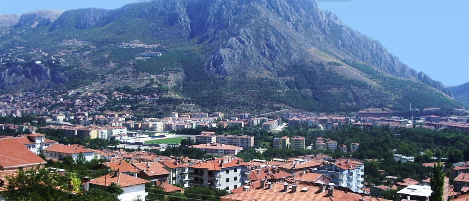
Mount Ferhat and Amasya at its foot. The channel runs down to the city along the
northern foot of this mountain, from left to right.1Hüseyin Menç Archive.
📜 What do the documents say?
A monumental water system about 18 km long, built in antiquity to bring
drinking water to Amasya.2 It runs west of the city, along the
northern foothills of Mount Ferhat, on the southern side of the Amasya–Tokat
highway. Starting in the west at the Helvacı neighbourhood, it runs east
towards the city centre; it is best seen at the spot called “Ferhat
Arası”.1
Although its first building phase has been pushed back as far as the Kingdom of
Pontus or the Hellenistic period,3 in its architecture and engineering it
is largely a work of the Roman period (1st–2nd century AD). An inscription on
a stone reused in the wall of the nearby Yörgüç Paşa Mosque says that the
channel was repaired; that repair dates to the 3rd century AD.1
The Amasya-born geographer Strabo (63 BC – AD 21) describes his own city in
minute detail — but never mentions this channel.1, 2
The channel was registered as a protected monument in 1992. In 1997 the Amasya
Museum carried out excavation and clearance work at the Ferhat Arası spot in the
Helvacı neighbourhood. Most of what is known today comes from that work.1
🗣️ What do the people say?
The channel is famous less for its architectural grandeur than for being the
setting of the legend of “Ferhat and Şirin”.4
Ferhat is a master painter who decorates palaces. He falls in love with
Şirin, sister of Mehmene Banu, the Sultan of Amasya.
Not wanting to give Şirin to him, the Sultan sets an impossible condition:
he must bring the waters of Şahinkaya, kilometres away, to Amasya by
piercing the great mountain.
Ferhat splits the mountains. Just as he is about to bring the water into the
city, a witch-like woman sent by the Sultan appears before him: Şirin is
dead, she says — and she offers him a false halva (in Turkish custom,
halva is made when someone has died).
Saying “If Şirin is gone, life is forbidden to me”, Ferhat throws his heavy
pickaxe (külünk) into the air. He dies from the blow when it falls
on his head.
Hearing his cry, Şirin comes running; unable to bear the pain, she too dies
beside Ferhat. The two lovers are buried side by side on this mountain —
and the mountain takes the name Mount Ferhat.
It is said that every spring two roses bloom between the two graves; but a
“Kara Diken Çalısı” (black thornbush) that grows up between them — it stands
for the witch — keeps them from ever meeting.4
red rose
BLACK THORNBUSH
white rose
This section is a folk narrative, not a document.
Look at the marks in the rock
In the 1997 excavation the rock surfaces were examined. The result: the channel had
been cut by striking metal chisels by human strength.1
So — kilometres of rock, no machines, no explosives. A man, a chisel, a mallet. And he
had to do it without breaking a gradient of seven centimetres in a hundred
metres: drop too much and the water speeds up and wears away the channel; drop
too little and the water does not flow at all.1
At Ferhat Arası, bend over the open parts of the channel.
The chisel marks are still there. The legend tells of one man piercing a
mountain. The rock tells a story too — but of how many?
How was it built?
The figures below are measurements from the 1997 excavation and survey drawings.1
0.07%The channel's gradient. Seven centimetres in a hundred metres.
90 cmAverage width of the open sections of the channel.
1.90 mAverage internal height of the vault — you could walk inside.
40 cmThickness of the vault. Rubble stone, corbelled.
3 cmThickness of the plaster on the floor: mixed with brick dust, waterproof.
3–4 cmDepth of the settling basins cut into the floor — they cleaned the water.
The channel was mostly made by cutting into the bedrock; where the ground was
unsuitable, masonry walls were built, supported here and there by buttresses. Inside
the city it ran entirely underground. On both sides of the open sections there
are flat ledges 80 cm above the channel floor and 20 cm wide: these are the
springing of the vault. In its original state the whole line was covered by a
vault.1
The channel went out of use by the 12th century AD at the latest. The
excavation found, next to the channel, an apsed building with a mosaic floor and a
burial space — thought to date to around the 11th–12th centuries AD, when the
channel was no longer working.1
Where does the mountain's name come from?
Amasya's two city historians part ways on this question. This page does not take
sides.
Mustafa Vâzıh Efendi · 19th c.
The author of the first city history of Amasya, asked “Is the water channel on
the Ferhat Rock the channel that Ferhat cut?”, replies:
“This channel is most probably the water channel that Ferhat opened.”5
He adds that in Amasya the Ferhat Rock is also called “Bîsütûn Dağı” and
“Temennâ Dağı”.5
Abdizade Hüseyin Hüsameddin · 20th c.
He criticises this view. In his opinion the name comes not from the legend but
from a commander: Ferhad Gâzi.6
When Emir Ahmed Danişmend Gazi besieged Amasya in 1075, Ferhad Gâzi led one of
the columns; he advanced over Mount Pont towards the Çakallar
area.7 According to Hüsameddin he fell as a martyr in that fighting and
was buried there. The mountain, known as Mount Pont even in the
Roman period, therefore came to be called Mount Ferhat.6
Where did the water come from?
The channel's source is still not certain. There are two candidates.1
Şahinkayası · 22 km
According to Hüseyin Hüsameddin, the source is the Şahinkayası, south of
Akyazı village, 22 km from the city. The channel ended at Ahırönü, south of
the Kibrithane (match factory), in a square cistern cut into the rock, 4 m on each
side.1
Kırkgöz · 24 km
Near Gözlek village, in the bed of the Çekerek stream, a channel was found that
matches the Ferhat water channel in building technique and level; clean
spring water was running through it. Starting from this, some argue that the
source was the Kırkgöz spring, 24 km from the city.1
Either way, the route would have had to cross the Deliçay on an aqueduct
bridge. No such bridge has been found yet. It is thought it may lie beneath the
foundations of an Ottoman bridge over the Deliçay near Dadı village — but that is a
question for future archaeological work.1
Note: in the legend, the condition the Sultan sets Ferhat is to bring the
waters of Şahinkaya.4 One of the candidates in the debate about the
source is also called Şahinkayası.1 The two texts share the same
name — this page draws no conclusion from that; it only sets them side by side.
How much of it could the travellers trace?
For centuries the channel caught the attention of travellers coming to Amasya. Each
could follow a different length of it — because parts of the channel had been buried
under earth.1
Traveller
Year
What they recorded
Tavernier
1632
Built over 1 mile (~1.6 km) by cutting into the edges of the rock face.
Evliya Çelebi
1645
This water channel supplies the southern part of the city and its fountains.
Ker Porter
1819
5 miles (~8 km).
Lennep
1854
The most interesting historic monument in Amasya; still in good condition in the second half of the century.
Reclus
1875–92
He does not describe it in his text but marks it on his map.
The Cumont brothers
1900
More than 1 m deep; 1 league (~6.2 km) can be traced;
not only cut into the rock but in places built on walls.
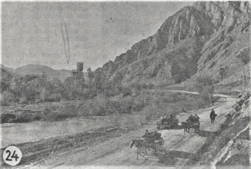
Ferhat Arası, 1939. The spot where the channel is best seen.1
Photograph: Cemal Işıksel. Hüseyin Menç Archive.
While you are there, look for
The chisel marks. The rock was cut by hand, with metal chisels.1
The ledges on either side of the channel. 80 cm above the floor, 20 cm
wide. A vault once rested on them.1
The rectangular hollows in the floor. Settling basins — the water's
sediment sank to the bottom here.1
The plaster. The reddish part is mixed with brick dust:
Rome's waterproof plaster.1
The wall of the Yörgüç Paşa Mosque. The stone carrying the channel's repair
inscription was reused there.1
The mountain itself. Where its name comes from is still disputed —
see above.5, 6
Key facts
Period
Roman period, 1st–2nd century AD1
Repair
3rd century AD — according to the inscription in the wall of the Yörgüç Paşa Mosque1
Length
About 18 km2
Gradient
0.07%1
Source
Disputed — Şahinkayası or Kırkgöz1
Went out of use
By the 12th century AD at the latest1
Registration
1992 — Ankara Regional Board for the Protection of Cultural and Natural Assets1
Excavation
1997 — Amasya Museum, directed by Ahmet Yüce1
Best seen at
Ferhat Arası (Helvacı neighbourhood)1
Location
40.632782, 35.813988 — verified against OpenStreetMap
Every factual statement on this page rests on one of the sources below.
Titles are given in their original Turkish so that they can be found;
quotations from them are our translations.
Feyza Aykutlu, Roma Dönemi Sonuna Kadar Amasya'da Su Yapıları (İstanbul: Yıldız Teknik Üniversitesi Fen Bilimleri Enstitüsü, Doktora Tezi, 2023), 197-203.
Kani Kuzucular, Amasya Kentinin Fiziksel Yapısının Tarihsel Gelişimi (İstanbul: İstanbul Teknik Üniversitesi Fen Bilimleri Enstitüsü, Doktora Tezi, 1994), 8, 17.
Merve Karakulak, XVIII. Yüzyılın İkinci Yarısında Amasya'nın Gündelik Hayatı (Şer'iyye Sicillerine Göre) (Ordu: Ordu Üniversitesi Sosyal Bilimler Enstitüsü, Doktora Tezi, 2022), 19-20.
Mustafa Güler, Amasya Efsaneleri (Amasya: Eser Ofset, 1996), 8-13.
Mustafa Vâzıh Efendi, Amasya Fetvaları ve İlk Amasya Şehir Tarihi (El-Belâbilü'r-Râsiyye fî Riyâzi Mesâili'l-Amâsiyye) (Amasya: Amasya Belediyesi, 2014), 84-85.
Hüseyin Menç, Tarih İçinde Amasya (Amasya: Amasya Belediyesi, 2014), “Pont Dağı'ndan Ferhat Dağı'na” bölümü; aynı bilgi Menç'e dayanılarak: Ersel Oltulu, Amasya'nın Anıtsal Eserleri ve Hızır Paşa Külliyesi Restitüsyon ve Koruma Önerisi (İstanbul: Yıldız Teknik Üniversitesi Fen Bilimleri Enstitüsü, Yüksek Lisans Tezi, 2006), 10. — Oltulu: “It is known that the name of Pon Mountain was changed to Ferhat Mountain in memory of Ferhat Gazi, who fell as a martyr during the siege of the city.”
Fatih Kertil, Büyük Selçuklu Döneminden Osmanlı Yönetimine Kadar Amasya Tarihi (Samsun: Ondokuz Mayıs Üniversitesi Sosyal Bilimler Enstitüsü, Yüksek Lisans Tezi, 2014), 26. — citing as its source Abdizade Hüseyin
Hüsameddin, Amasya Tarihi, vol. 2, pp. 166-167.