Adım Adım Amasya

Water and Healing Route · Stop 2

Kumacık Bathhouse

A small bathhouse — but it was not built for its own sake. It was endowed so that its income would go to a mosque, a madrasa and a school. So someone washing here was, without knowing it, paying for a student's education.

1494–1495 Ayas Ağa, Lesser Agha of the Gate Reopened in 1991
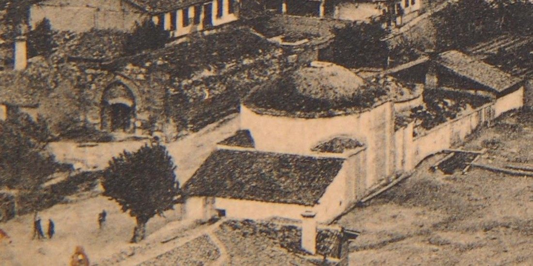
Detail of an old panorama of Amasya: a large domed building inside a courtyard wall and, on the left, a pointed-arched portal
From an old panorama of Amasya. According to the archive's caption, this picture shows the Kumacık Bathhouse and the Jesuit School. The domed mass inside the courtyard wall and, on the left, a pointed-arched portal can be made out. Hüseyin Menç Archive. Because no source confirms which dome in the picture belongs to the bathhouse, the domes are not marked one by one here.

📜 What do the documents say?

The building is in the Bayezid Paşa neighbourhood, level with the Künç Bridge. It was built in 1494-1495 by Ayas Ağa (Ayas Paşa), the Lesser Agha of the Gate.1

In 1495 it was endowed to the Ayas Ağa Mosque, Madrasa and School, to bring them income.2 So the bathhouse was the source of income of a charitable foundation: the money collected here kept the mosque, the madrasa and the school going.

Over its history it came through various disasters. Restoration began in 1987, and it reopened in 1991.3

How did Kocacık become Kumacık?

Ayas Ağa had bought the plot for the bathhouse from Kocacık Hoca Ahmed Çelebizade Hoca Mehmed Çelebi. That is why the bathhouse was first called “Kocacık” or “Komacık”; over time, in popular speech, the name changed to “Kumacık”.1

Kocacık→ Komacık→ Kumacık

Mustafa Vâzıh Efendi, who wrote the first city history of Amasya in the 19th century, records the same thing: “They call it the Kumacık Hamamı. This is said as a corruption of the name Kocacık.”4

The name of the man who sold the plot has won out over the name of the man who bought it. Today nobody calls this bathhouse the “Ayas Ağa Hamamı”.

Small, but with a different plan

Kumacık is a small bathhouse — and in one respect it departs from the classic scheme.5

Square planThe changing hall is square in plan.
4 iwansIwans around the main dome.
2 halvetsUnlike the classic plan with four halvets, there are two halvet cells here.
Wall-length furnaceThe furnace (külhan) runs along the wall of the hot room.

The record sums it up like this: the building is a small bathhouse consisting of a square changing hall, a warm room, and four iwans around the main dome with two halvet cells. Unlike the classic plan with four halvets, small chambers have been added to the warm room, and its furnace runs along the wall of the hot room.5

What is a halvet? A small private bathing room in the corners of the hot room, where one person can shut themselves in. Classically there are four. Here they have been reduced to two, and the remaining small chambers have been added to the warm room — that is, the architect stretched the scheme on a narrow plot.5

In order

Count the halvets

In an Ottoman bathhouse you would expect four halvets in the corners of the hot room. Here there are two; the remaining small chambers have been added to the warm room.5

If you can go inside, stand in the hot room and look at the corners. How many small rooms that can be closed off can you count? If the number is fewer than four, the reason is not a clumsy architect: the plot was narrow, and the scheme was stretched to fit it.

Then turn to the door and look across: the Künç Bridge is right in line with you.1 They have been looking at each other for five hundred years.

While you are there, look for

Key facts

Period
1494–14951
Commissioned by
Ayas Ağa (Ayas Paşa), Lesser Agha of the Gate1
First names
Kocacık, Komacık1
Owner of the plot
Kocacık Hoca Ahmed Çelebizade Hoca Mehmed Çelebi1
Endowed to
1495 — the Ayas Ağa Mosque, Madrasa and School2
Plan
Square changing hall, warm room, four iwans, two halvets; furnace along the wall5
Restoration
Begun 1987; reopened in 19913
Position
Bayezid Paşa neighbourhood, level with the Künç Bridge1
Coordinates
40.65748, 35.836238 — verified against OpenStreetMap
In the book
Kültürel Miras Boyutuyla Amasya, p. 53

📍 Open on the map

Sources

Every factual statement on this page rests on one of the sources below. Titles are given in their original Turkish so that they can be found; quotations from them are our translations.

  1. Fuat Er, XV. ve XVI. Yüzyılda Amasya (Elazığ: Sosyal Bilimler Enstitüsü, Yüksek Lisans Tezi, 2009), 64, 109.
  2. Amasya Harşena Dağı ve Pontus Kral Kaya Mezarları Alan Yönetim Planı ve UNESCO Dünya Mirası Başvuru Dosyası (Amasya: Amasya Belediyesi, 2022), 92.
  3. Edip Uzundal, Sultan II. Abdülhamid Dönemi'nde Amasya Sancağı (Sosyal, Ekonomik, İdarî ve Demografik Yapı) (Tokat: Gaziosmanpaşa Üniversitesi Sosyal Bilimler Enstitüsü, Doktora Tezi, 2017), 183.
  4. Mustafa Vâzıh Efendi, Amasya Fetvaları ve İlk Amasya Şehir Tarihi (El-Belâbilü'r-Râsiyye fî Riyâzi Mesâili'l-Amâsiyye) (Amasya: Amasya Belediyesi, 2014), 75.
  5. Ersel Oltulu, Amasya'nın Anıtsal Eserleri ve Hızır Paşa Külliyesi Restitüsyon ve Koruma Önerisi (İstanbul: Yıldız Teknik Üniversitesi Fen Bilimleri Enstitüsü, Yüksek Lisans Tezi, 2006), 53.
The identification of the photograph is not certain. The present state of the building, and whether the picture on this page shows this bathhouse, await confirmation on site. The coordinates have been verified.