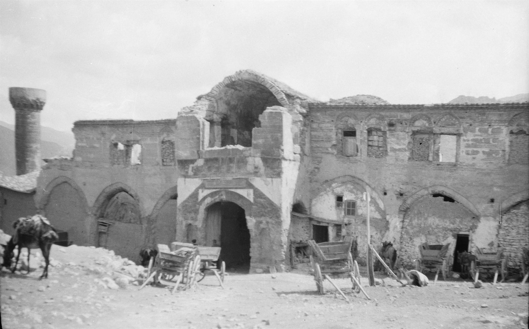
The most thoroughly documented building on this route.
Its account books recorded, one by one, how many rooms and shops it had and how many
kuruş it earned a year.
1699Rahtuvan Hacı Mehmet PaşaArchitect Ferhat Kalfa
The courtyard, at work. Two-storey arcades, a collapsed vault over the
main gate, horse carts in the courtyard and, on the left, a laden camel.
At the far left you can see the minaret of the Burmalı Minare
Mosque — the source says the inn was near that mosque.1Taşhan archive.
📜 What do the documents say?
The Taşhan, with a 300-year history in Amasya, was built in 1699 for
Rahtuvan Hacı Mehmet Paşa, the governor (mutasarrıf) of the time, by
the architect Ferhat Kalfa.2
That is why it appears in the waqf account books as “the Taşhan, known as
the Rahtuvan Hanı”.1
It is an inn (han) spread over a large area, two-storeyed, with a wide
courtyard, rectangular in plan and with six domes. It stands near the
Burmalı Minare Mosque, in the Hoca Süleyman neighbourhood
— later called “the burnt ground” (yangın yeri)
— beside the Grain and Straw Market.1
The figures in the ledger
Account records of 1837-1844 count the inn room by room:1
34Rooms on the lower floor.
29Rooms on the upper floor.
63Rooms in all.
24Shops adjoining the inn.
6Domes.
2Storeys.
How much did it earn?
Year
Annual income
1838
3,250 kuruş
1840
about 4,000 kuruş
This income was collected from the inn's occupants and from the 24 shops adjoining
it. In those years the waqf's trustee, Lütfullah b. Osman, one of the
founder's descendants, helped with the accounts.1
What was sold around it?
According to the records, beneath the four sides that formed the outside of the
inn were the markets of these trades:1
Silk merchants
Turban-cap makers
Perfumers
Cotton merchants
The goldsmiths were counted separately: 32 goldsmiths' shops, 16 adjoining
the inn and to its north and 16 under the arch. Next to these and to their
left were another 12 shops belonging to the cotton-beaters' bazaar.1
And a curious detail: a street ran through the middle of the inn.1
So the Taşhan was not a closed courtyard but a building that the city passed
through. It is also said that the makers of the “Halebî arşın”
(the Aleppo ell) had been settled here from of old.1
The small mosque in the middle of the courtyard
Rahtuvan Mehmed Paşa endowed this inn, which he had built of stone, to his
descendants. His son Hacı Ahmed Bey built a small mosque
(mescit) in the middle of the inn in 1766, with an ablution
fountain beneath it.1
The inn also had a vault for keeping treasure, because it stood in the middle of
the city.1 It is also said that in 18th-century records the
Taşhan appears as a “bazaristan”.1
So this building was at once an inn, a bazaar, a mosque, a fountain and a treasure
vault. According to the records, it was ruined by earthquakes from time to
time.1
In order
1699
Rahtuvan Hacı Mehmet Paşa has the inn built by the architect Ferhat
Kalfa.2
1766
His son Hacı Ahmed Bey builds a small mosque in the middle of the
courtyard, with a fountain beneath it.1
1837–44
The account records: 63 rooms, 24 adjoining shops, an annual income of
3,250–4,000 kuruş.1
today
It has been restored, and part of it serves as a hotel.1
Count the rooms
Go into the courtyard and look at the arcades of the two storeys. According to
the record there were 34 rooms below and 29 above.1 How many can you
count today? The restoration and the hotel layout may have changed the number —
and the difference is information too.
Then look at the middle of the courtyard. Once there was a small mosque
there, with a fountain beneath it.1 Can you find any trace of it
today?
And finally, under the arches: 16 goldsmiths' shops lined the north side, and
16 more were under the arch.1 In the photograph above, the horse carts and
the laden camel in the courtyard are a reminder that this building was not a museum
but a place of work.
While you are there, look for
The two-storey arcades and arches.1
The six domes. That is their number, according to the record.1
The middle of the courtyard. The site of the 1766 mosque and
fountain.1
The gate arches. The goldsmiths' shops were under the arch.1
Every factual statement on this page rests on one of the sources below.
Titles are given in their original Turkish so that they can be found;
quotations from them are our translations.
Mehmet Fatih Becerik, XIX. Yüzyıl Ortalarında Amasya Şehrinin Sosyo-Ekonomik Yapısı (İstanbul: İstanbul Üniversitesi Sosyal Bilimler Enstitüsü, Doktora Tezi, 2022), 335.
Orta Karadeniz Kalkınma Ajansı (OKA), Kültür Rehberi (Erişim 12 Şubat 2026).
The date of construction and the name of the architect await confirmation. These two pieces of information come from an institutional publication; checking them against an academic source is still under way.