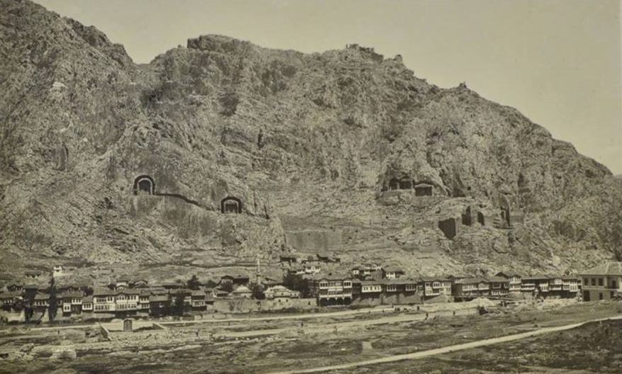
This is where the eye of anyone arriving in Amasya first catches. These huge
hollows carved into the rock face are tombs — the Rock Tombs of the Kings — and
a geographer born here wrote about them two thousand
years ago.
Hellenistic periodKingdom of PontusUNESCO Tentative List, 2015
The tomb façades on the rock face. You can count them from left to right:
the large arched openings, then the smaller ones. Above, the castle walls;
below, the Yalıboyu mansions lined along the riverbank.
Hüseyin Menç Archive.
📜 What do the documents say?
On the skirts of Amasya Castle, they are monumental
burial chambers made by carving into the rocks on the slopes of Mount
Harşena that face the Yeşilırmak.1
The ancient geographer Strabo also refers to them, as the
“monuments of the kings”. Their number has generally been put at
between 16 and 20; the largest five of them belong to the Pontic
kings of Persian origin.2
The monumental tombs are surrounded by “U”-shaped galleries,
and they are entered by a door opening in the middle.3
🗣️ What do the people say?
In Mustafa Güler's collection these tombs are described like this — not as a
legend, but as a history the city tells itself:
“Rocks are seen, mostly facing north, rising like a flat wall on what was
then called ‘Harşene Dağı’. Carving and digging into the
rocks, which are limestone and very hard, they made the ‘Kral Kaya
Mezarları’.
These, it is said, were the tombs in which the Pontic kings, who once held
these lands, were buried. These tombs, which catch the eye of anyone who
first comes to Amasya and attract a great deal of attention, are still
protected and preserved today.”
Read the original Turkish
“Genelde kuzeye bakan; o zamanki ismiyle ‘Harşene Dağı’ düz
bir duvar misali yükselen kayalar görülür. Kalker ve oldukça sert olan kayalar
oyularak kazılıp ‘Kral Kaya Mezarları’ yapılmış.
Bir zamanlar buraları elinde bulunduran Pontus Krallarının gömülü oldukları
mezarlarmış bunlar. Amasya'ya ilk gelenin gözüne ilişen ve oldukça ilgi çeken
bu mezarlar, bugün bile korunur ve saklanırlar.”
Mustafa Güler, Amasya Efsaneleri; English translation
ours.4
Note: the folk narrative and the documents say the same thing — this time
there is no divergence. On this page the dispute arises over whom the
tombs belonged to; see below.
The man born here wrote about this place
Strabo was from Amasya. In his Geography, describing his own city, he
mentions these rocks. What you will read below are the sentences of someone who
looked at this view two thousand years ago — in his own words.
Strabo reads his own lines
Dramatisation
Strabo
64 BC – AD 21 · geographer from Amasya
STRABO
Tap the box to continue
Not a single word here is ours.
Every sentence you have read above is Strabo's own
(Geography XII.3.39); only the picture and the voice are ours.
The English is the published translation by H. L. Jones (Loeb Classical
Library, 1928). On the Turkish page, the two opening sentences come from
Adnan Pekman's translation,5 and the rest from the text quoted in the
Site Management Plan.6
The drawing was made separately, inspired by ancient dress; it is not an animation
of a statue or a work of art.
A correction: In the Turkish translation, the
sentence about the cisterns goes on “but it is not possible for the city to
make use of these sources”. Strabo's text says the opposite: the city
cannot be deprived of this water, because two channels have been cut, one
towards the river and one towards the neck.7 That is why the Turkish page
stops the sentence at that point; the English above gives it in full.
Three things Strabo lists are still in place today: the two peaks and the narrow
ridge between them, the cisterns carved into the rock, and the water
channels carved into the rock. A fourth — the
Ferhat Water Channel — interestingly, does not appear
in his account at all.
Who lies here?
The five large tombs are accepted as belonging to the Pontic dynasty.2
The founders of the dynasty and what they are known to have done:6
Mithradates II337–302 BCSon of Ariobarzanes. Killed by Antigonos Monophthalmos.
Mithradates I Ktistes302–266 BCRegarded as the founder of the kingdom. He makes the fortress of Kimiata
his base, and takes Amaseia and makes it his capital.
Ariobarzanes266–250 BCTakes Amisos (Samsun).
Mithradates II250–220 BCMarries Laodike, daughter of Antiochos Theos, for a Seleucid alliance.
Becomes known in the Greek world by sending aid after the Rhodes earthquake of
227/226 BC.
Mithradates III220–197 BCLittle is known of his short reign; but on the coins struck in his name the
symbol of the kingdom, the crescent and star, begins to appear.
Pharnakes I197–160 BCFollows an aggressive policy: takes Sinope, Kotyora and Kerasus.
Moves the capital to Sinope.
What does “Mithradates” mean?
The word that gave the dynasty its name comes from the Persian god
Mithra and means “gift of Mithra”.6
What the book calls “of Persian origin”2 is right here,
inside the name.
Be careful with the numbers. The numbering of the Pontic kings is disputed in
the literature: even the Site Management Plan gives the founder two names,
“Mithradates III or Mithradates I Ktistes”.6 The book,
for its part, lists the five tombs as those of Mithradates I, Ariobarzanes,
Mithradates II, Mithradates III and Pharnakes.2 This page does not
claim which tomb definitely belongs to whom.
What if they are not the Pontic kings?
A historical objection on this point is on record. This page takes no side.
The kings of Pontus
This is the common view: the largest five tombs belong to the Pontic kings of
Persian origin; Strabo, too, speaks of the “monuments of the
kings”.2
The kings of Cappadocia
According to Busbecq, the famous 16th-century envoy and traveller, however,
these tombs belong to the Kings of Cappadocia.8
Beyond the five
Within the boundaries of the management area, besides the five royal tombs,
there are other rock tombs carved into the bedrock.6 Two are particularly
interesting:
Rock tomb no. 6
In the Hatuniye neighbourhood, where the rocky ground begins, north of the pointed,
conical rock. It is reached by two small stone steps; it is square in plan,
with a flat ceiling. What sets this tomb apart from the others is this: in every
wall except the entrance façade, shelf-like burial benches have been carved. In
front of the north wall, on the right and left, are offering pits carved into the
floor. Just 2 metres to its right is an oval water cistern, 10 m deep,
carved into the bedrock.6
Rock tomb no. 7
On Hazeranlar Street, right next to tunnel no. 25 of the railway. On its
west-facing façade there is a three-step krepis stair, a podium and, on it, a
rectangular naos; between the anta walls, with two rectangular prismatic
supports, a Greek temple façade of the “in antis” type has been
formed. Above the triangular pediment rise two stepped forms. Among the rock tombs
of Amasya, a façade with two supporting piers at the entrance appears for the first
time in this tomb.6
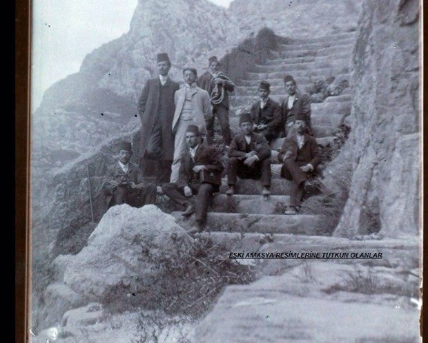
1895. A group posing on the steps carved into the rock in front of the
Kralkaya Tombs. The stair has been cut out of the rock itself — the people in the
photograph give you the scale.
Old Amasya archive.
Count the façades
From the opposite bank — from the Alçak Bridge or level
with the Yalıboyu houses — look at the rock face. How many monumental façades can
you count? According to the records there are between 16 and 20 tombs in
all; the largest five can be made out even from a distance.2
Then choose one and look at the gallery around it: the tombs are surrounded by
a “U”-shaped gallery, and the door opens right in the
middle.3 This is not a room hollowed out of the rock — it is a
free-standing monument cut out of the rock. That is, it was made not by adding
stone but by taking stone away.
In the evening the tombs are lit up. Then count them again.
Excavations and UNESCO
1999First excavation on Mount Harşena — Amasya Museum.
2009Excavations continue under the direction of Prof. Emine Naza Dönmez.
201513 April — UNESCO World Heritage Tentative List.
2021Management area boundaries and 20 connection points approved.
The Site Management Plan puts its reasoning like this: because they are well
preserved and unaffected by modern change, the tombs are authentic enough to
reveal the royal resting place of the Kingdom of Pontus, about which we have only
limited archaeological knowledge. In this respect, the place that best
defines the Kingdom of Pontus is Mount Harşena.6
While you are there, look for
The “U” galleries around the façades.3
Where the door is. It opens right in the middle.3
The steps carved into the rock. The stair in the 1895 photograph is still
there.
Up at the castle and the
Kızlar Sarayı. Strabo writes that the
palaces and the tombs are in the same area.6
The grooves in the rock face. Strabo says that two tube-like
channels were hewn out: one towards the river, one towards the
neck.6
Down at the Yalıboyu. Two thousand years fit into the same frame.
Key facts
Period
Hellenistic period — Kingdom of Pontus2
Number
Generally 16–20 tombs; the largest five royal2
Belonging to
Disputed — the kings of Pontus or of Cappadocia2, 8
Technique
Carved into the bedrock; “U”-shaped galleries, central doors1, 3
First record
Strabo, Geography XII.3.396
Excavations
Since 1999; since 2009 under Prof. Emine Naza Dönmez6
UNESCO
13.04.2015 — World Heritage Tentative List6
Location
40.652995, 35.829145 — verified against OpenStreetMap
Every factual statement on this page rests on one of the sources below.
Titles are given in their original Turkish so that they can be found;
quotations from them are our translations.
Feyza Aykutlu, Roma Dönemi Sonuna Kadar Amasya'da Su Yapıları (İstanbul: Yıldız Teknik Üniversitesi Fen Bilimleri Enstitüsü, Doktora Tezi, 2023), 128.
Kani Kuzucular, Amasya Kentinin Fiziksel Yapısının Tarihsel Gelişimi (İstanbul: İstanbul Teknik Üniversitesi Fen Bilimleri Enstitüsü, Doktora Tezi, 1994), 17.
Orkan Zeynel Güzelci, Amasya Yalıboyu Evleri Üzerine Bir Biçim Grameri Çalışması (İstanbul: İstanbul Teknik Üniversitesi Fen Bilimleri Enstitüsü, Yüksek Lisans Tezi, 2012), 49.
Mustafa Güler, Amasya Efsaneleri (Amasya: Eser Ofset, 1996), 13-16. — The section “Aynalı Mağara Efsanesi”; the description of the Kralkaya Tombs is here.
Strabon, Geographika: Antik Anadolu Coğrafyası XII-XIII-XIV, çev. Adnan Pekman (İstanbul: Arkeoloji ve Sanat Yayınları, 2000), 49-52, naklen Ali Tuzcu, Seyahatnâmelerde Amasya (Amasya: Amasya Belediyesi Kültür Yayınları, 2007), 6-7. — On the Turkish page, the two sentences at the opening of the narration: “Benim memleketim Amasya…” and “İnsan emeği ve doğa…”
Amasya Harşena Dağı ve Pontus Kral Kaya Mezarları Alan Yönetim Planı ve UNESCO Dünya Mirası Başvuru Dosyası (Amasya: Amasya Belediyesi, 2022), 23-24, 35-43. — The Strabo quotation (XII.3.39), the Pontic dynasty, rock tombs nos. 6 and 7, the excavations and the UNESCO process.
Strabo, The Geography of Strabo, tr. Horace Leonard Jones, Vol. V (Loeb Classical Library, 1928), XII.3.39. — “The rock also has reservoirs of water inside it, a water-supply of which the city cannot be deprived, since two tube-like channels have been hewn out, one towards the river and the other towards the neck.”
Ogier Ghiselin de Busbecq, İstanbul ve Amasya Seyahatnamesi (İstanbul: Alfa Yayınları, 2021), 185.
Which tomb belongs to which king is not known. The sources do not agree on matching them one by one; that is why the page gives no names.