Adım Adım Amasya

Water and Healing Route · Stop 5

Alçak Bridge

This bridge was not built low. The river rose. Its name (alçak means low) records something about the riverbed, not about the bridge itself.

Roman in origin Masonry piers, timber deck In line with Kızlar Sarayı
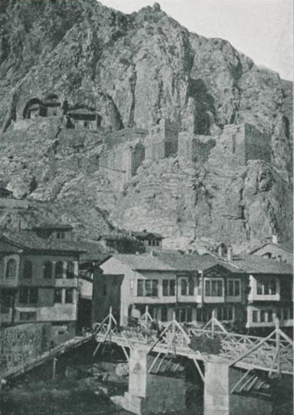
The Alçak Bridge with timber railings on stone piers; riverside houses behind, castle walls and the royal rock tombs on the cliff above
The Alçak Bridge. Masonry piers, a timber superstructure — exactly as the book describes it.1 Behind, the riverside houses; above, the royal rock tombs carved into the cliff and the castle walls. The book says the bridge stands in line with the Kızlar Sarayı2 — and the picture shows it. From the magazine Şehbal; Hüseyin Menç Archive.

📜 What do the documents say?

It was built over the Yeşilırmak in the city centre to provide a crossing from Amasya Castle to the neighbourhoods opposite. It stands in line with the Kızlar Sarayı.2 Its piers are of masonry, its deck of timber.1

Its story begins with its original Roman form; in the 19th century it went through great changes.3, 4

Where does the name come from?

Over time the riverbed rose.
The bridge's arches ended up below the water level.

That is why people called it the “Alçak Köprü”, the Low Bridge.3

So the name is a record not of how the bridge was built but of how the river behaved: over the centuries the Yeşilırmak deposited the silt it carried at this point and raised its own bed. The bridge stayed where it was; the water came up to meet it.

How many times was this bridge destroyed?

Note: you will meet Ziya Paşa on this route and in many places in the city. In the same years (1864) it was he who built the Government House, the municipal offices, the prison, the telegraph office and the clock tower, and who had the banks of the Yeşilırmak walled in stone and turned into a modern promenade.5 The same Ziya Paşa also inspected the silk factory of the Alaman Farm in 1865.

Look at the water, search for the arch

What explains this bridge's name is the part you cannot see. The arches ended up under the water.3

Go to the edge of the bridge and look down. In a season when the water is clear and low — late summer, early autumn — you may make out the upper line of the arches. If you can't see them, you have still learned something: that is how high the river has risen.

Then lift your head. Right in front of you, on the face of the rock, are the Kızlar Sarayı and the royal rock tombs.2 You are standing in line with them.

While you are there, look for

Key facts

Origin
Roman period3, 4
Present form
1882 — masonry piers, timber deck3, 4
Why the name
When the riverbed rose, the arches ended up under water3
Location
In line with the Kızlar Sarayı, city centre2
Earlier rebuilding
1865 — Governor Ziya Paşa, timber bridge3, 4
Coordinates
40.651913, 35.83061 — verified against OpenStreetMap
In the book
Kültürel Miras Boyutuyla Amasya, p. 55

📍 Open on the map

Sources

Every factual statement on this page rests on one of the sources below. Titles are given in their original Turkish so that they can be found; quotations from them are our translations.

  1. Ahmet Caner Çatal, 19. Yüzyılın İkinci Yarısında Amasya Şehri'nin Demografik Yapısı ve İskân Siyaseti (Niğde: Niğde Üniversitesi Sosyal Bilimler Enstitüsü, Yüksek Lisans Tezi, 2009), 10.
  2. Millî Eğitim Bakanlığı, “Alçak Köprü”, Okul Dışı Öğrenme Ortamları (Erişim 11 Ocak 2026).
  3. Abdizade Hüseyin Hüsameddin Yasar, Amasya Tarihi, 4 Cilt (Ankara: Amasya Belediyesi Kültür Yayınları, 1986), 103, 106.
  4. Amasya Harşena Dağı ve Pontus Kral Kaya Mezarları Alan Yönetim Planı ve UNESCO Dünya Mirası Başvuru Dosyası (Amasya: Amasya Belediyesi, 2022), 62.
  5. İlber Ortaylı, Tanzimat Devrinde Osmanlı Mahalli İdareleri, 4. Baskı (Ankara: Türk Tarih Kurumu, 2020), 80. — Building works of Ziya Paşa's time.