Adım Adım Amasya

Water and Healing Route · Stop 7

İstasyon Bridge

The oldest dated bridge on the route: 1145. It was destroyed in an earthquake and rebuilt — but the book's two sources do not agree on the year of that earthquake.

1145 · Seljuk Mesud I Sultan Bridge
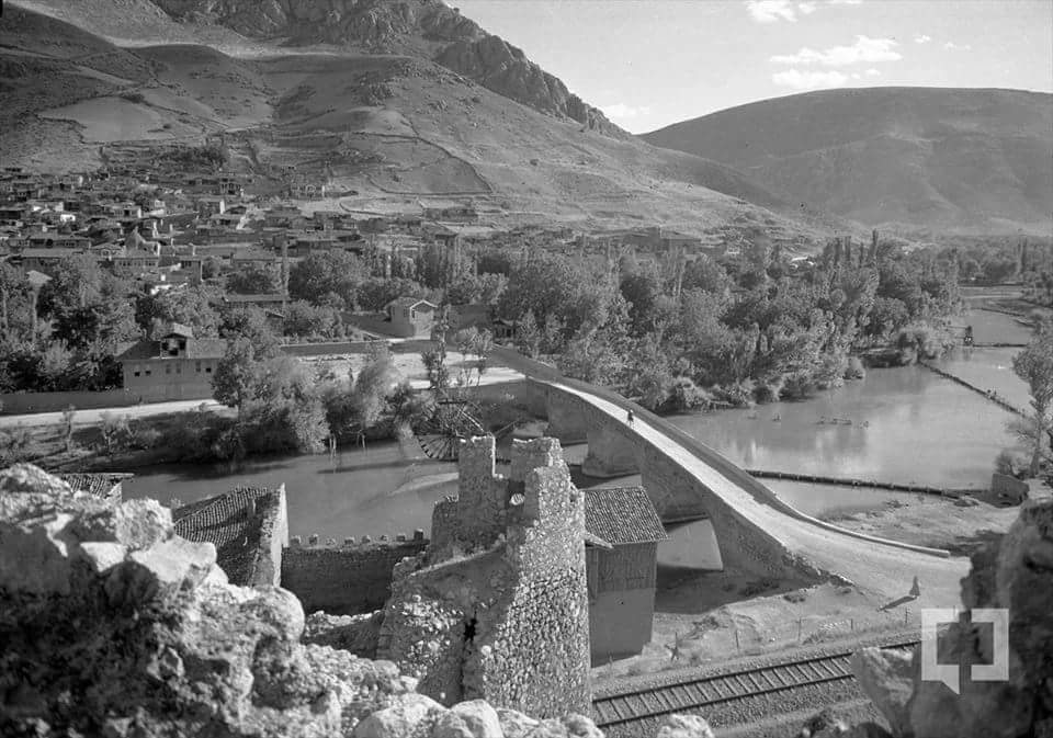
A long dressed-stone bridge over the Yeşilırmak with a rising back; the railway at the bottom right, the city on the left, bare hills behind
İstasyon Bridge. Its harpuşta back, rising in the middle, and its dressed-stone body are clearly visible.1 At the bottom right, the railway — the bridge's present name comes from it (istasyon: station). The view is taken from the remains of a castle wall or tower in the foreground. Hüseyin Menç Archive.

📜 What do the documents say?

At the western entrance of the city, it links the Hacı İlyas neighbourhood to the İstasyon (Station) area. In historical sources it also appears as the “Sultan Köprüsü” (Sultan Bridge).2

It is recorded as having been built first by the Seljuk Sultan Mesud I in 1145 (AH 540).2 It is built of dressed stone, with 5 spans, arched, in the harpuşta manner.1

The structure was last repaired in 1828 by Özlü Yusuf Ağa, the ayan (leading notable) of Amasya.1
🗣️ What do the people say?

There is a narrative not about this bridge — but about the ground around it. In Mustafa Güler's collection, as the Kurtboğan narrative is being told, the place is described like this:

“If you come to Amasya and cross the İstasyon Bridge — towards the stadium, and the station included — they say that both sides were an old cemetery; you will hear it said. Nowadays these places have become residential areas; the railway station, too, was built on the site.”

Read the original Turkish

“Amasya'ya gelip İstasyon Köprüsü'nden geçerseniz; stada doğru ve istasyon dahil; her iki tarafın eski mezarlık olduğunu söylerler; işitirsiniz. Şimdilerde buralar yerleşim yeri olmuş; tren istasyonu da alana yapılmıştır.”

Mustafa Güler, Amasya Efsaneleri — the Kurtboğan narrative; English translation ours.3

This section is a folk narrative, not a document. The narrative itself is about Kurtboğan; the part quoted here is only a description of the place.

Which earthquake destroyed the bridge?

There is an interesting situation here: two of the book's own sources put the same event in different years. This page takes no side; both are shown.

The 1319 earthquake

The bridge was destroyed in the earthquake of 1319; it was rebuilt first in timber, and then in masonry by Şadgeldi Paşa in 1368.2

The 1374 earthquake

The bridge was destroyed in the earthquake of 1374; it was rebuilt in dressed stone, preserving the building character of Şadgeldi Paşa's time.1

The two accounts cannot both be true: in one the rebuilding is in 1368, in the other the destruction is in 1374. What they share is this: the bridge was built in 1145 by Mesud I, destroyed in an earthquake, and reborn in dressed stone in a period associated with Şadgeldi Paşa. This page states what they share and does not hide where they part.

The structure

5 spansThe number of arched openings.
Dressed stoneThe material of the body.
HarpuştaA back that rises in the middle and slopes to either side.
1828The last known repair — Özlü Yusuf Ağa.

What is harpuşta? A hump-backed profile in which the middle of the bridge rises and slopes down to either side. In the photograph above this back is clearly visible. Its purpose is both to leave a high opening for flood water and to balance the load of the arches.

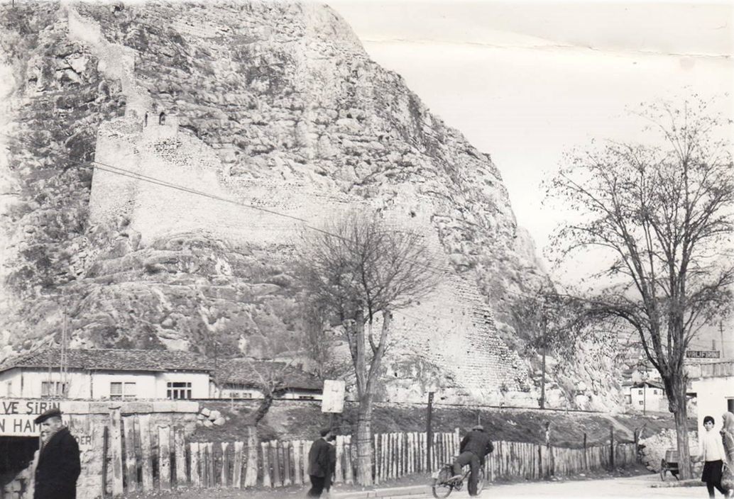
The İstasyon bridgehead: castle walls on the rock face, a wooden fence, a man with a bicycle and shop signs
The İstasyon bridgehead. Castle walls climbing the rock face, a wooden fence, a man with a bicycle. On the sign on the left you can read “...VE ŞİRİN” (‘...and Şirin’) — the name of Ferhat and Şirin has found its way even onto the city's shop signs. Hüseyin Menç Archive.

What is under your feet?

The narrative says something very clear: once you cross the bridge, towards the stadium and including the station, both sides are said to have been an old cemetery; today these places have become residential areas, and the railway station was built on that site.3

Cross the bridge and stop. Around you are the station building, a sports ground, houses. The narrative says there is something else beneath this ground. We have no document that confirms it — but the narrative itself is a record too: the city has not forgotten what lies beneath it.

While you are there, look for

Key facts

First built
1145 (AH 540) — the Seljuk Sultan Mesud I2
Rebuilt
Period of Şadgeldi Paşa — year disputed1, 2
Other names
Sultan Köprüsü; Meydan Köprüsü2
Structure
Dressed stone, 5 spans, arched, harpuşta1
Last repair
1828 — Özlü Yusuf Ağa, ayan of Amasya1
Position
The western entrance of the city; between the Hacı İlyas neighbourhood and İstasyon2
Coordinates
40.65205, 35.822945 — verified against OpenStreetMap
In the book
Kültürel Miras Boyutuyla Amasya, p. 58

📍 Open on the map

Sources

Every factual statement on this page rests on one of the sources below. Titles are given in their original Turkish so that they can be found; quotations from them are our translations.

  1. Amasya Valiliği, “Köprüler” (Erişim 12 Şubat 2025).
  2. Fuat Er, XV. ve XVI. Yüzyılda Amasya (Elazığ: Sosyal Bilimler Enstitüsü, Yüksek Lisans Tezi, 2009), 40.
  3. Mustafa Güler, Amasya Efsaneleri (Amasya: Eser Ofset, 1996), 17-19. — The description of the place in the section “Kurtboğan Hazretleri ve Efsanesi”.